







I recently received the following intriguing letter, via my publisher. It contains a small weather mystery in the final paragraphs. Please do get in touch if you can solve.
21 September 2025
Dear Tristan,
How To Read Water
I have just read HTRW, which was recommended to me by a friend. I found it compelling reading and fascinating. The subject matter is very wide, much more than just water, and I thoroughly enjoyed it.
A brief note on why I found it so interesting. I am 75, a retired Master Mariner. Nautical College Pangbourne from 1963, P&O Cadet from 1967, Manchester Liners from 1974, then Oil rigs from 1983. Control Room Operator until 1987, then Bargemaster and Offshore Installation Manager with Houlder Offshore, Foramer S.A., and Transocean until 2000. Became Self-employed as Marine Consultant with Trident Offshore and worked as Tow Master, Marine Representative for rig moves, plus other stuff – dockyard project manager, consultant on a windfarm barge laying export electric cable, safety and suitability surveys for various types of vessel, etc.
I have spent a lot of time over the years looking at the water and the skies, and always took a lively interest in what I saw. There were several things that I particularly enjoyed from your book. Chief of these was a proper scientific explanation for the green flash, which I had not been able to find, even in the marine meteorology book from the HMSO. I’ve seen it at least six times. Your analogy of the street lights for taking sights is masterly. I always enjoyed taking sights but welcomed the acceptance of calculators by the examiners for working them out in the 70s! Tables are fine, but it did take away the struggle of getting the numbers right from Burton’s or Norie’s tables . . .
You also mentioned the issues with water of different densities. We had a severe problem on a rig in the South China Sea off the Pearl River with internal waves. We were about 120 miles off the coast drilling in 850 ft water depth. The rig was listing unexpectedly, first one way, then the other, and causing the driller problems on the rig floor. Ths would happen at about 40 minute intervals. We checked for causes within the rig (perhaps flooding of a crossbrace member) but found nothing. It turned out to be Solitons, or Internal Waves, which caused upwelling at the surface and currents strong enough to raise bow-waves round wires in the water. I would guess 1.5 to 2 knots.
I have a couple of stories that might interest you. The second of these will only be appreciated by people who know how to take sights.
Firstly, we were engaged to conduct a number of rig moves of an American Jack-up rig in Trinidad in the mid 2000s. These were invariably away from and back alongside fixed platforms, usually on the Atlantic side on the East coast. Because of the risk of damage to the platform – we had to position the rig within just a few feet of the platform to permit the drilling package to be skidded out over it – and the strong ocean current there, we needed really good weather with an upper limit on sea height of 1.5m or so. As a result we often spent a long time waiting on weather to go alongside. In some cases, weeks. Each day I would go and check on the wave heights several times, usually by watching the waves on the legs of the nearby platform. Their ladders on the legs helped a lot here. Drilling personnel would very helpfully come and tell me that the waves were going down, sometimes sevral times a day, and I would ask them “How long did you watch?” Never more than five minutes was always the answer. I would give it at least twenty or thirty minutes, since there was usually several big ones in that time. Since the fetch for that location was 2500 miles in the NE trades all the way from Africa, it took a long time for changes to occur. The Oil Company was naturally concerned with the delay, but accepted the judgment I made about moving. One day they posed a question: we received two commercial weather forecasts from the USA. They always agreed with the significant sea height, but gave a higher figure as well. One forecast would say Sig Sea Ht 2.5m, occasionally 2.8m, while the other would say Sig Sea Ht 2.5m, Random 3.0m. This difference was always there, always the same, one forecast higher than the other, by the same ratio. The Oil Co. wanted to know why?
I said, “I don’t know, but I’ll find out”. So I spoke to both forecast providers and did some searching on the internet. I learnt a great deal about wave spectra. I already knew the Significant Sea Height was the average of the highest 1/3 of the waves, I then learnt that the theoretical maximum wave height was about 2.0 times the significant wave height, but that that might only occur once in three days. Any height in between would occur at intervals proportional to the factor of the difference. Thus a wave of 1.15 x SSHt would occur more often than a wave of 1.20 x SSHt. It turned out that the two companies were using different factors for the higher figure. I noted that neither of them referred to the higher figure as “maximum” height. The Americans do have to be so careful about litigation, don’t they?

The other story took place on my last trip with P&O in 1972/3. At this time P&O had done away with the twenty or so shipping companies within the group and bunched them into trades – General Cargo, Passenger, Ferries, Containers and Tankers. I was sent to join a New Zealand Shipping Co. freezer ship on a voyage to New Zealand. General cargo out, Freezer cargo back. The skipper was the most ignorant mariner I ever met. How he got a Master’s Certificate, I do not know. He could do the calculations but had no understanding whatever of any theory. This applied to stability, cargo stowage and navigation. He had an alarming habit of “needing to make a good departure” from the coast and would go perilously close to the shore to get it! He had the dangerous quirk of never, ever admitting he was wrong, and would stick to his guns even if it put the ship in danger. He was also, sadly, the caricature of a mean Scot. Anyway, this story involved taking sights. He was the only Master I sailed with who would take sights every day on the ocean passage. The ship was built in 1946 and had a wooden bridge and chart room. The chronometers were in their glass-topped box on the chart table, so he would come up after breakfast, take three sights together and call “Stand By . . . . . . Stop” to me (Third Mate) so that I could record each time. He would then go down to his cabin and come up again at noon for meridian passage. He worked out his position using the “Long.-by-Chron” method. Now, myself and the Second Mate had to do our sights then enter the noon position, day’s run, course made good, Av. Spd, ETA, etc. on a card,which we passed to him in the chart room. He would then compare them, and say “Aye, we’ll call it so-and-so”, for the noon position. The Captain was puzzled by a discrepancy that kept occurring. About one day in three I would differ from the rounded up noon latitude from the other two. The reason for this was that for this noon calculation I worked to the nearest 0.1 of a minute, and they, for some reason, worked to 0.5 of a minute for each figure, the sextant altitude, declination and corrections. This was apparently standard practice on NZS ships. The Second Mate explained this to the Captain, but he didn’t understand. So the 2/O did the two calculations side by side, and he STILL didn’t understand it. I should say that the Second Officer was having a very hard time with this skipper, who changed all the positions and courses he had laid out, and wanted all sorts of pointless things from him. I didn’t help matters by sticking my head through the hatch and saying it was probably because I was working more accurately than them. The Captain stormed off, the Second Mate started throwing books around the chart room.
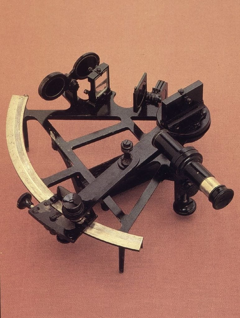
I calmed down Henry and sent him off to have some lunch, promising to fix the Captain for him. The next day the Captain came up and took his three morning sights. I added four seconds to his time. The next day I added eight seconds to his time. The next day, 12 seconds. This of course sent the Captain’s position away from ours at a rate of one mile a day. He was puzzled and when he started correcting his position in his book, I went the other way, deducting 4, then 8, then 12 seconds from his time. He was clearly mystified why his position was acting in this way. I should say that we were way out in the Pacific, miles from land, so there was no danger to the ship. Henry knew something was going on but couldn’t see what it was. Eventually he said to me “What are you doing?”, and I told him. “Crikey, he’ll kill you if he finds out!” He said. I replied, “Henry, if you explained it to him he wouldn’t understand it”. So all the way across the Pacific, the Captain swung east and west from the real noon position and couldn’t make it out. How gratifying! Somehow we survived and safely returned to the UK.
Finally, how about this for a strange weather observation? 1976 or thereabouts. Second mate (12 to 4 watch), 1400 in the afternoon somewhere mid Atlantic between the St. Lawrence and the UK. Great Circle route so well north of other traffic, very rare to see another ship. Weather conditions, wind about 10 knots, sunny and fine, just a bit of fair weather cumulus in the sky. Very quiet, my lookout off working with the bosun somewhere. Just a rare pleasant day in the North Atlantic. I noticed that the horizon looked a bit fuzzy up ahead so put the radar on. No ships about anywhere. As we got closer, the fuzzyness appeared as a fog bank. Lying about 45 degrees across our course. When we were about a mile off it, I spotted a small break in the bank, just 5 degrees off our course line, where I could see the horizon through it. Nobody around, so I tweaked the autopilot and headed for the gap. We passed through. The fog bank was about 200 feet high and maybe 300 yards wide, straight line, horizon to horizon. Like a hedge. Just the one break near our course line. No disturbance visible in the water, nothing in the sky to explain it, wind remained unchanged either side. What could cause that?
Sorry to go on at such length, but an audience for stories like these is very rare. No reply is looked for, but drop me an e-mail if you get it OK. In the unlikely event that you wish to use any of these tales in a future book or a revised edition, please feel free.
Many thanks,
“Horatio”
(The author’s name has been changed, by request, to Horatio. )
Dear Horatio,
Thank you for reading my book and your very interesting letter, forwarded by my publisher.
I can’t currently confidently explain the peculiar fog formation sadly, but a reason there must be!
Could the gap have been caused by an earlier ship passing? (The nautical equivalent of what is called a ‘distrail’ in the aviation/cloud world).
Tristan
I don’t think the gap in the fog bank could have been caused by another ship, there was nothing on the radar within 24 miles. Puzzling. Nature is wonderful isn’t it?
Horatio